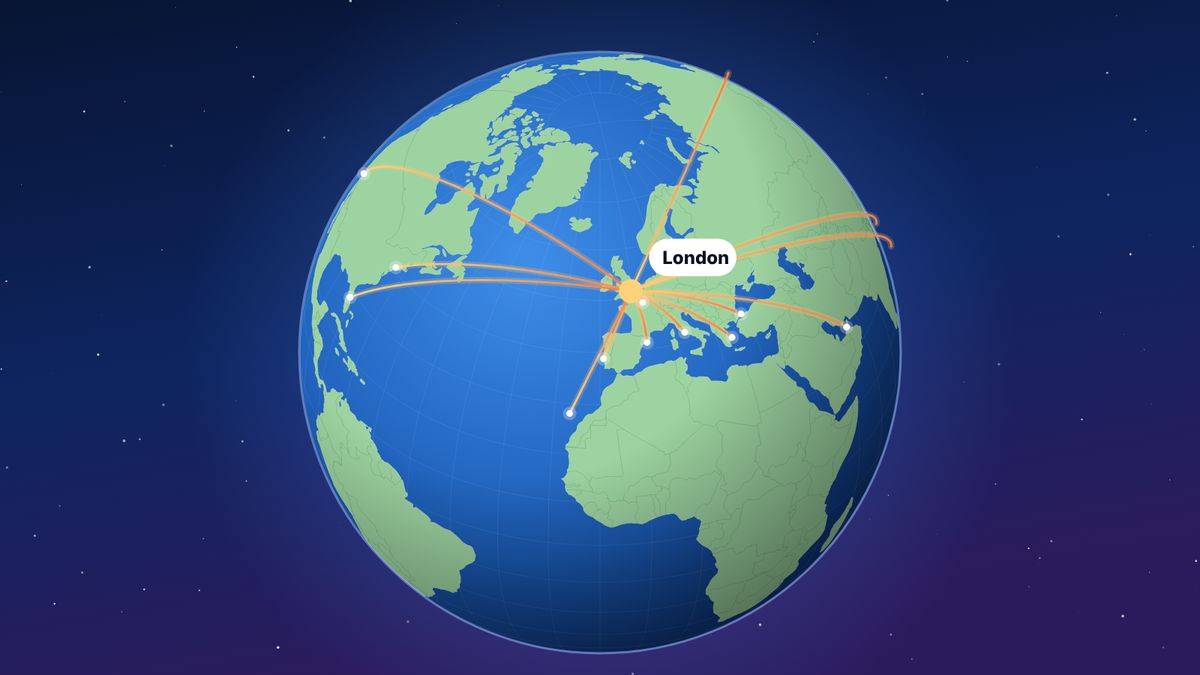
The great-circle distance is the shortest distance between two points on the surface of a sphere, measured along the surface. For flights, it is the shortest path between two airports over the Earth, and it is the standard way to measure flight distance: London Heathrow to New York JFK is 5,540 km. On a flat map that path looks curved towards the pole, because flat maps stretch the regions near the poles. Real flights are usually a few percent longer than the great-circle distance, because of winds, airways and air traffic control.
Look at a flight map on a seat-back screen and the route from Europe to America swings up towards Greenland in a big arc. It looks like a detour. It is actually the shortest way. This guide explains why, how the distance is calculated, and what it means for the distances you see in flight logs.
What is a great circle?
A great circle is any circle drawn on a sphere whose centre is the centre of the sphere. The equator is one. So is every line of longitude, together with its opposite. Slice an orange exactly through the middle, in any direction, and the cut edge is a great circle.
Between any two points on a sphere, the shortest path along the surface lies on the great circle that passes through both. That path is the great-circle route, and its length is the great-circle distance.
Why the route looks curved
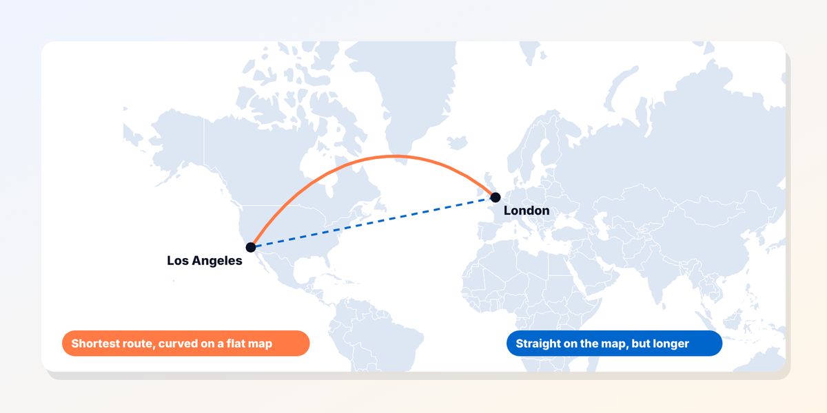
Most world maps use projections that flatten the globe into a rectangle. The most familiar, Mercator, keeps compass directions straight, which made it ideal for sailors, but it stretches everything near the poles. Greenland looks as big as Africa on a Mercator map; in reality Africa is about 14 times larger.
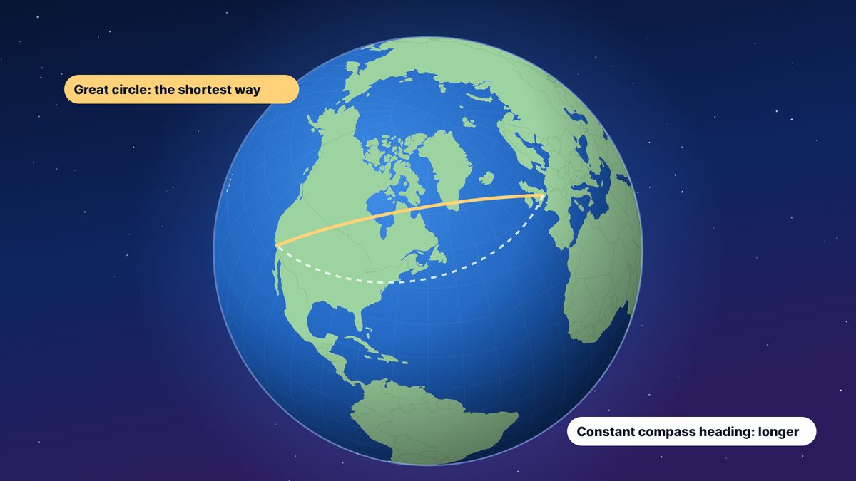
Because of that stretching, a great-circle route between two places in the northern hemisphere bulges towards the North Pole on a flat map. On a globe, the same route is straight.
An example. The great-circle route from London Heathrow to Los Angeles leaves London heading north-west, not west, and reaches a highest latitude of about 62° north, over Greenland and northern Canada, before curving south towards California. Following a constant compass bearing instead, which looks straight on a Mercator map, would be noticeably longer.
The same is true from London to New York: the great-circle distance is 5,540 km, while a route on a constant compass heading (a “rhumb line”, straight on a Mercator map) is about 5,760 km, around 4% longer.
How great-circle distance is calculated
The usual method is the haversine formula. It takes the latitude and longitude of two points and the radius of the Earth, and returns the distance along the surface.
In words:
- Convert both latitudes and longitudes from degrees to radians.
- Work out the differences in latitude and in longitude.
- Combine them: a = sin²(Δlatitude ÷ 2) + cos(latitude₁) × cos(latitude₂) × sin²(Δlongitude ÷ 2)
- The central angle between the points is c = 2 × asin(√a).
- The distance is d = R × c, where R is the Earth’s radius.
Most flight tools use the mean Earth radius of 6,371 km. The Earth is slightly flattened at the poles, so more precise methods, such as Vincenty’s formula on an ellipsoid, can differ by up to about 0.5%. For flight logs, the haversine result is more than accurate enough, and it means everyone gets the same number for the same route.
A worked example: London to New York
| Latitude | Longitude | |
|---|---|---|
| London Heathrow (LHR) | 51.4707° N | 0.4599° W |
| New York JFK | 40.6394° N | 73.7793° W |
Plugging these into the haversine formula with R = 6,371 km gives 5,540 km (3,442 miles, or 2,991 nautical miles). You can check any pair of airports with the free flight distance calculator, which also draws the route on a globe.
Kilometres, miles and nautical miles
- Kilometres are used in most of the world and in flew.world by default.
- Statute miles (1 mile = 1.609 km) are used in the United States and the UK, and by many frequent flyer programmes.
- Nautical miles (1 nautical mile = 1.852 km) are used in aviation and at sea. One nautical mile is very close to one minute of latitude, which is why pilots and navigators like it.
flew.world lets you switch between kilometres and miles; the underlying distance stays the same.
Why real flights fly further
The great-circle distance is the minimum. The distance actually flown is usually a few percent longer:
- Airways. Aircraft follow published routes between waypoints, a little like motorways in the sky.
- Winds. Over oceans, airlines plan routes each day to use tailwinds and avoid headwinds. The North Atlantic tracks between Europe and North America move daily with the jet stream, so the fastest route is not always the shortest.
- Airspace restrictions. Closed or avoided airspace can add hundreds of kilometres to some routes.
- Departures and arrivals. Climbs, descents and holding patterns near busy airports add distance.
- Rules for twin-engine aircraft. Over remote oceans, routes must stay within a set flying time of a suitable diversion airport, which can bend them away from the great circle.
This is why an airline or a flight tracker may show a slightly higher distance than a flight log. Neither is wrong: one measures the shortest path between the airports, the other the path actually flown.
A few great-circle surprises
- London to Tokyo flies over Scandinavia, Finland and the Arctic coast of Siberia when the airspace is open, not over the Middle East.
- Flights from the US West Coast to Asia pass close to Alaska, because the great circle across the North Pacific curves north.
- New York to Hong Kong is shortest over the North Pole region, one reason polar routes opened up for passenger flights.
- Two points on opposite sides of the Earth, such as Madrid and Wellington, have infinitely many great circles between them, all the same length: about 20,000 km, half the Earth’s circumference.
Why flight logs use great-circle distance
- It is consistent. The same route always has the same distance, whoever flew it and whatever the wind did that day.
- It needs no tracking data. Only the two airports.
- It is comparable. Your total can be compared with anyone else’s who uses the same method.
flew.world uses great-circle distance for every flight and says so on every total. Flight times are your recorded times where you have them, and otherwise an estimate of 800 km/h plus 30 minutes, labelled as estimated.
Questions
What is great-circle distance?
The shortest distance between two points on a sphere, measured along its surface. For flights, it is the shortest path between two airports over the Earth.
Why do flight routes look curved on maps?
Flat maps stretch the regions near the poles. A straight path on the globe between two northern cities appears as a curve towards the pole on a flat map.
How is flight distance calculated?
Usually with the haversine formula, from the latitude and longitude of the two airports and a mean Earth radius of 6,371 km.
Why is the distance flown longer than the great-circle distance?
Aircraft follow airways, use or avoid winds, steer around restricted airspace and fly approach patterns near airports. The difference is usually a few percent.
How far is London to New York?
The great-circle distance from London Heathrow to New York JFK is about 5,540 km (3,442 miles).
Updated 2 November 2026. Spotted something out of date? Tell us at hello@flew.world.